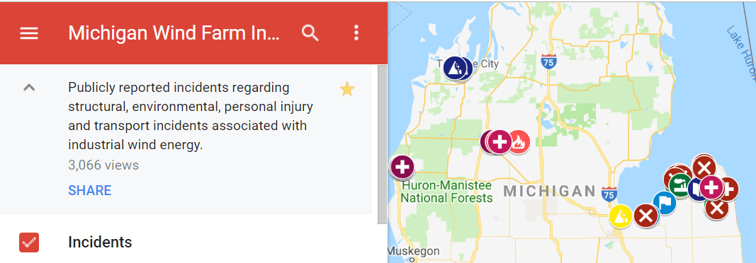
Map from Michigan Wind Farm Accident Map Compiled by thumbwind.com from public data and news sources. Contains incidents, accidents and failures in industrial wind farms within the State of Michigan. Information responsibility of Caithness Windfarm Information Forum and source acknowledged at http://www.caithnesswindfarms.co.uk CAITHNESS WINDFARM INFORMATION FORUM

View map: Wind farm foes release project sight analysis
View map: Wind farm foes release project sight analysis FEB 1, 2019 | JOSHUA VISSERS | The Mining Gazette The Friends of the Huron Mountains (FOHM) has released a sight analysis of the proposed Summit Lake Wind Project (SLWP) in Baraga County developed with help from the Geospatial Research Facility at the Great Lakes Research Center … Continue reading View map: Wind farm foes release project sight analysis

Press Release: FRIENDS OF THE HURON MOUNTAINS Virtual Reality Viewer
FOR IMMEDIATE RELEASE Friends of the Huron Mountains Release Viewshed Analysis 2D Maps & 3D Virtual Reality for Proposed Summit Lake Project L’Anse, Michigan, January 30, 2019 The Friends of the Huron Mountains, a group in opposition to the proposed Summit Lake industrial wind farm in the Huron Mountains, announced today that a sophisticated project … Continue reading Press Release: FRIENDS OF THE HURON MOUNTAINS Virtual Reality Viewer

Preliminary topographical turbine viewshed.
Preview of coming attraction - we are having accurate topographical maps and 3-D views created to show the turbine viewshed. This preliminary example is based on just 2 turbines. They would be visible from any area shown in red. 47 more to follow. Not only during the day, but aviation lights will also be installed … Continue reading Preliminary topographical turbine viewshed.

Project Location Maps
Various Project Maps.
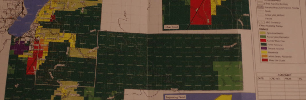
Extent of Forest District Land in L’Anse Township.
This is NOT about ONE project (Summit Lake). If they change the zoning to allow 500+ ft wind turbines in the forestry district, they will be allowed to be constructed with a special use permit in ANY of the area shaded dark green on this map (they already are allowed in the lightest green)! History … Continue reading Extent of Forest District Land in L’Anse Township.

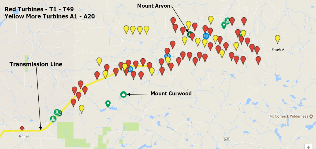
FAA information for Proposed Turbines
Details for the Proposed Industrial Turbine Locations From 2018 FAA Applications 12/4/2018 Determined cases are on hold as a petition was filed and accepted for a discretionary review. View on google map Case Number Links to FAA Information Latitude Longitude Site Elevation Name/FAA Map Determined 2018-WTE-6439-OE 46° 41' 32.33" N 88° 18' 12.50" W 1795 T1 11/21/18 … Continue reading FAA information for Proposed Turbines
Useful Tools
Some Useful Tools Used. Google Maps. Google Map of Turbine Locations for the Summit Lake Project MiWaters Water Resources Information and Forms: MiDEQ Waters Permits Online Federal Aviation Administration, Obstruction Evaluation FAA Search - See Proposed FAA information HERE Michigan Office of Aeronautics Michigan Tall Structures and Met Towers NOAA Weather Radar Siting Tool NOAA NEXRAD Screening Tool … Continue reading Useful Tools
Proposed Industrial Turbine Locations – 2018
RES - Turbine location update. August 10, 2018 All of the Original 131 Cases have been terminated, at this time RES does not have any locations approved by the FAA. On July 07/06/2018 there were 69 proposed Cases submitted to the FAA for Wind turbines. There are 2 sets of Cases a group with structure names … Continue reading Proposed Industrial Turbine Locations – 2018

NREL: Wind Maps
This collection of wind maps and assessments details the wind resource in the United States. If you have difficulty accessing these maps because of a disability, contact the Geospatial Data Science Team. Wind Prospector This GIS application supports resource assessment and data exploration for wind development. Wind Speed Maps U.S. Annual Average Wind Speed at 30 … Continue reading NREL: Wind Maps
