
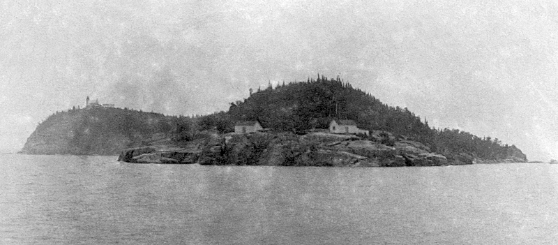
Huron Islands Wilderness
Eight small islands, totaling 147 acres, make up the Huron National Wildlife Refuge. It is located just three miles off the south shore of Lake Superior in Marquette County, Michigan. Huron National Wildlife Refuge was established in 1905 as a refuge and breeding ground for migratory birds and other wildlife, especially the herring gull, which has large nesting colonies on the islands. These early, bird sanctuaries were vital for a number of species of birds, including the herring gull, whose populations had been drastically reduced by plume hunters and egg collectors in the 1800s and early 1900s.
Huron National Wildlife Refuge was established as a refuge and breeding ground for migratory birds and other wildlife, especially the herring gull, which has large nesting colonies on the islands. These bird sanctuaries were vital for a number of species of birds, including the herring gull, whose populations had been drastically reduced by plume hunters and egg collectors in the 1800s and early 1900s.
Location
The islands are located 3 miles off of the south shore of Lake Superior and 18 miles east of the Keweenaw Peninsula. 46 57’44.14″ N 87 59’56.05″ W
Latitude: 46.9633
Longitude: -87.9983
Read More:
U.S. Fish & Wildlife Service: About the Refuge, Wildlife, Visit
Wikipedia: Huron Islands
Huron Islands Wilderness, at Wilderness Connect
Huron Islands – Keweenaw Geoheritage
Huron National Wildlife Refuge. stateparks.com
The Lighthouse
Huron Island Lighthouse. Michigan Lighthouse Conservancy
Huron Island Light Station
Huron Island Lighthouse – Lighthousefriends.com
Huron Island Lighthouse – Travel Marquette
Huron Island Lighthouse USFWS PDF


Lighthouse Restoration
Efforts to Save Huron Island Light. lighthousedigest.com
Story appeared in the October 1999 edition of Lighthouse Digest
Marquette Underwater Preserve – Huron Island Unit Sites
| Site name | Type | Depth (ft) | Depth (m) | Coordinates |
| Arctic | Wooden Sidewheel Steamer | 5–100 | 1.5–30.5 | d46°57.74′N 87°59.85′W |
| George Nester | Wooden Schooner-Barge | 20–100 | 6.1–30.5 | 46°57.99′N 88°00.20′W |
| Southwest | Wooden Schooner | 100 | 30 | 46°56.42′N 87°56.11′W |
| Launch Huron Island | Wooden Gas Launch | 15 | 4.6 | 46°56.42′N 87°56.11′W/a> |
